

Arch. Marco Buinhas,
Design Director of enCity
Hanoi, the captivating capital of Vietnam, is a city steeped in history and culture. Its name, meaning “River’s Embrace,” reflects its intimate relationship with the Red River and the numerous lakes that grace its landscape. These waterways have shaped Hanoi’s identity, providing sustenance, enabling transportation, and serving as a precious natural landscape amidst the bustling urban life.
The devastating impact of Super Typhoon Yagi in September 2024, causing immense loss and hardship for the people, serves as a stark reminder for us to reconsider our relationship with rivers and cities.
I. HANOI
Hanoi is the apex of Red River’s delta, located within the floodplain of the Red River, a historical corridor of intensive rice agricultural fields. Hanoi has shown traces of early settlements dating back to around 5,000 years ago. The origin of Hanoi as an administrative center can be traced back to the seventh century. In its early stages, the city consisted of a small trading area situated next to the Citadel. For many centuries, trade control and a succession of dynastic conflicts determined its development. When the French settled in Hanoi in the late nineteenth century, the city had roughly 100,000 people, and urban growth remained slow under the new administration that nevertheless transformed its appearance and functions through the construction of the new “modern” urban neighborhoods, infrastructure, and modernized transport corridors such as railway. Later, during the early post-independence period and the resistance wars against the French 1946–1954) and the USA (1954–1975), further limited the development of the city. Nevertheless, by 1980, Hanoi’s total population had reached 1 million and the city was not to exceed this figure for almost three decades due both to the control of rural migration and the late economic crisis of the 1980s. From the 1990s onward, and after the economic liberalization reforms (Doi Moi), the population started to increase considerably.
The surface and administrative boundaries of Hanoi have changed several times throughout the twentieth century and in this process, especially after 2008, Hanoi’s land area triplicated from 921 to 3.328,9 square kilometers, integrating extensive agricultural zones that now constitute two-thirds of its territory. Hanoi’s old city core, once defined by the Citadel and Old Quarter, corresponds to 1 square kilometers.
The modernization and expansion of Hanoi since the end of the twentieth century gradually resulted in the loss of its historical value as a riverine city by neglecting the role of the river as a fundamental artery and heritage component, a heart of social, cultural, and patrimonial life.
II. RIVER RED – RED RIVER
The Red River is not only a source of life, but perhaps one of the most vital components of Vietnamese history, culture, and urban heritage. As an unstable fluvial system, the river has slowly changed its course over the past thousand years. This change is reflected in its color; dragged alluvium particles dying its waters with deep shades of red. It’s as much a river of water, as a river of memories and ideas; a lively entity carrying history, culture, agriculture, and folklore, bridging past and future, in a turbid boundary between men and nature, between the delta territory and the city. Coming from the far north, runs through 1,149 km, meandering for 510 km through steep mountains and highlands, where turbulent currents rule during the rainfall season, hitting the plains to the south at a lower elevation, becoming placid and gentle. Embedded in history, the Red River delta is the cradle of wet rice cultivation and of the northern typical village culture. The relatively stable components of the delta are its mountains and geological deposits; everything else has changed over time, including climate and landscape changes, the shifting of fluvial courses, erosion and deposition, soil development, and degradation. The combination of these dramatic changes had historically shaped the development of the main trade routes. River travel used to dominate transportation, and the Red River proved to be not only a transport artery but a lucrative trading and commercial route, until the opening of the Kunming–Haiphong Railway in 1910.
The popular image of the Red River still relies on the idea of a fierce river associated with major floods along its course. Thus, the Red River has always been considered an element to be tamed, and the construction of dikes for embankment protection has taken place since early throughout history. The river, culturally credited as a civilization cradle, has been historically perceived as a ‘physically dangerous’ place during storms and floods. Initially established as a Citadel and trading settlement, Hanoi grew from a small harbor on the west embankment of the Red River to prosper as a city and later to expand as a metropolis. The city, however, has always faced flood risks due to the alluvial process raising the level of the waters above its elevation. Therefore, dikes are part of both the city and the Red River’s morphology.
The dike system has contributed to the protection of the city but also poses an obstacle, separating the city and river. In the last decades, Hanoi’s intensive urbanization, along with the instability of the Red River’s complex hydrological behavior, resulted in remarkable transformations in urban morphology, landscape, urban environment, and ecosystem. Under the influence of urbanization, parts of the Red River outside the dike had been rapidly occupied. The flood-prone areas along the embankment became a location of informal settlement, examples of the urbanization process close to the city center. The overdevelopment of such areas, causing serious erosion, threatening soil quality, and raising pollution risks is also considered one of the main reasons leading to increased flood vulnerability of not only the riverside urban areas but also the whole urban system.
The dike not only separates the city and the river; It divides urban life into two ‘out of sight, out of mind’ worlds, where despite being in close proximity, those inside the dike are unable to see or experience the river or the open landscape right before their eyes. Despite losing its significance as a transport artery and the livelihood of a trading stage, the Red River and embankment system still retains the potential of a central development axis for Hanoi.
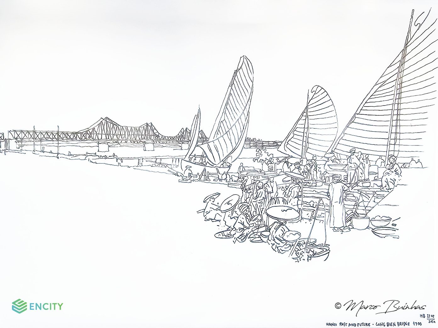 Figure 1. The author’s sketch of Hanoi and the Red River of yesterday.
III. THE DRAGON’S NAVEL
The thousand-year-old city of Hanoi is known as the “Dragon’s Navel” (Long Do). This name indicates both its location in the Red River delta and its altitude; being a large extension of modern Hanoi, including the area of the royal palace, seated lower than the average of the Red River delta. In the period between the third century BC and the eighth century AD, Hanoi was still covered by lakes and ponds, enveloped by thick forests. The ponds, lakes, and backwaters of the Red River, upon which Thang Long Citadel was raised, witnessed the process of human construction and the shrinking of forests and water surfaces. These long-gone forested areas are still recalled in toponymics as Gia Lam (Good Forest), Truong Lam (Long Forest), Mai Lam (Flower Forest), and Dong Ngan (Mountain Forest).
The Citadel’s spatial organization depended on force lines oriented from west to east (gates / Red River) and from north to south (parallel alignment with Red River and successive dikes). Networks of successive roads and dikes were progressively channeled into the Red River, freeing up extensive areas for the trading quarters, enabling the slow expansion of the city’s core towards the hearts of the city blocks where village elements remained (lakes, temples, and village boundaries).
These road and dike systems made up the fundamental framework for the future clusters of urban development. The first markets must have been set up at the intersection between roads, dikes, and canals. The emergence and consolidation of the Citadel grounds during the first millennium was a significant phase in land siltation and the expansion of the western mid-Red River delta. During this period, the upper Red River areas experienced continued growth due to the more reliable rain-fed harvests of the tenth to the thirteenth centuries, and many large temples and pagodas were raised, while lots of palaces were built in the capital. All this suggests economic expansion, accumulated wealth, and population growth.
The impact of human activities and erosion on the upper Red River areas increased the frequency and severity of floods in the middle delta. These frequent floods and the need for protection of the Citadel motivated the consolidation of the dike system (Dinh Nhi) in the mid-thirteenth century.
From the very beginning, the Citadel and the adjacent commercial area, known as the Old Quarter, were merged to form the capital city, defining an administrative settlement and a business center. Preliminary located in the river floodplain, by the West Lake and the Red River, Hanoi has extended towards opposite directions and these water bodies had become a natural border at the east and northern parts of the city. A large marsh at Van Dien-Thanh Tri District is the farthest part southward of Hanoi. To Lich River, running from the lake to the south can be considered as the first border for the Hanoi urban and Nhue River as the father second one for the city westward. The western and southwestern areas are more open to expand than at the north, south and east directions, which are restricted by large water bodies and marshlands, fact that over periods conducted the expansion towards west and southwest. The growth of Hanoi has occurred gradually, in part taking shape from a dense substratum of villages that were slowly absorbed into its fabric and linked to a myriad of more distant peri-urban villages network. Owing to its ideal situation at the crossroads of major waterways, Hanoi was at the center of regional trade.
Water is present in all the districts of the city: the Red River, the other rivers, ponds, and canals form the city’s cultural fabric. These waterways not only sustain the patterns of local life but also invite visitors to be initiated into the city’s beauty. As major transportation arteries from the past, these waterways are still witnesses to centuries of history, influencing the territory and shaping change. Over time, they had modified the form of the city throughout its history: floods, changes in the configuration of the hydrographical and hydrological system, and successive earthworks and land reclamations. Even during the early twentieth century, colonial urbanism with its policy of large-scale reclamation, did not totally drain water from the city’s body, but made it a single-function element of aesthetic and romantic nature: the urban lake.
It can be concluded that Hanoi was raised not merely on land but between waters, therefore water should be a major element. However, the significance and role of the main river had changed substantially. Instead of being a vital artery, it has been forgotten, becoming a neglected body of water. From its position at the forefront, it has been pushed to the back, becoming a dumping ground and a site for sand mining instead of being honored and protected.
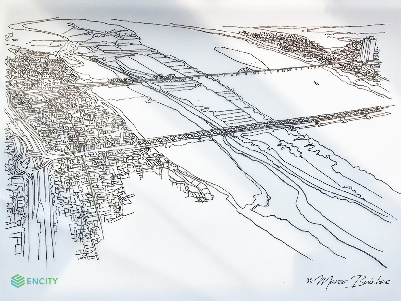 Figure 2. The author’s sketch of Hanoi and the Red River today (from left to right): the city, the dike, informal settlements, the river, and the midstream bank.
IV. A GREEN DEVELOPMENT AXIS
The challenges associated with urbanization in Hanoi are multifaceted and call for innovative solutions that are appropriate to this region’s history, context, and fundamental resources. If we miss the historical role of the river as a fundamental resource, it is not just a failure of perception – it is also a failure of imagination. Leveraging in the past, the Red River should be considered the key protagonist in the objectives of making Hanoi green (xanh), cultural (văn hiến), civilized (văn minh), and modern (hiện đại). Taking challenge as an opportunity, we must take into consideration the effective value of the River River, not only as a historical urban nurturing source but as a key to the city’s green sustainable future.
Among the problems to be tackled in parallel, are the impacts brought by hydrology and climate change, as a low-lying city near the mouth of a major and unpredictable river, as well as urban regeneration, public space provision, and transportation infrastructure development. These challenges must be turned into opportunities and that will demand combined actions to address: (1) Ecological Restoration, (2) Flood Protection, (3) Urban Regeneration, (4) Public Space Provision, and (5) Urban Transportation.
- Ecological Restoration
Hanoi is a “city of rivers and lakes” or “the city within rivers”. These rivers, and the Red River in particular, not only sustain local life, but are also witnesses to centuries of history, influencing Hanoi urban patterns and evolution.
The rivers not only play an important role in the city’s culture and history but also in a natural value, particularly important as green corridors and natural habitats, as well as the opportunities for conservation, sustainable agricultural development, and tourism experience on the alluvial plains and islets. They are key components of the ecosystem and are exposed to the impacts of climate change and human activities. As a result, their ecological functions and the ecosystem services they provide are threatened.
Ecological restoration is the first step towards the vision of the Red River corridor as a flood relief area, enhancing wildlife connectivity, improving ecological functions and exploiting the possibilities of a “green” development axis for central Hanoi.
- Flood Protection
Throughout the globe, the most critical impacts of climate change are likely to happen in urban areas where people, resources and infrastructure are concentrated. Located in a low-lying area at the mouth of the Red River, Hanoi occupies a vulnerable position, at great risk from current and projected climate hazards, especially flooding.
A dike system was built from north to south, along the two river embankments, historically defining an urban retention perimeter, segregating inner and outer areas, also separating the river from the city. The space between the main dike and the riverbank can be considered as an improper corridor for urban development, but during the last decades has been informally and densely occupied and urbanized. The flood risks are particularly critical in areas such as these, and others where spontaneous human settlements expanded to the floodplain outside the dike system and along the river edge. There is an urgent need to reevaluate the role played by natural systems within urban areas in providing specific mitigation and adaptation strategies, adapted to their population distributions and densities, economic activities, buildings and infrastructure.
Approaches need to be in place to ensure that floods or extreme events do not compromise urban functions and the safety of residents. At the same time, the need to consider a barrierless infrastructure to assure full accessibility and a proper and meaningful urban integration of the Red River embankment system. To be specific, it is also necessary to have solutions to respond to flooding hazards. We need to consider and calculate various alert levels, with Typhoon Yagi being the highest corresponding to Alert Level 2. For example: (1) Pedestrian bridges should be designed above the flood alert level. (2) Buildings should leave the first floor vacant, be built at the highest possible elevation, and the floor levels of the upper floors should all be higher than Alert Level 3. (3) The main rescue route should also be above the flood alert level. (4) The tourist boat system should have docking stations integrated with waterborne evacuation facilities.
- Urban Regeneration
During the twentieth century, Hanoi’s urban development remained mostly compact and spatially confined. In the last decade of the twentieth century with the opening of the economy, urban expansion began to accelerate, and the city’s fabric started to expand into peripheral areas and suburban districts. The speed of this expansion posed major challenges due to the intensive socio-spatial transformations, and new demands for urban infrastructure, services, land uses, and environmental control. The combination of informal urbanization and urban growth also brought a wide range of impacts on population and one of the issues associated with urban growth is related to forced appropriation and conversion of agricultural land into urban uses.
The problems associated with urbanization in Hanoi are complex and call for innovative and integrative solutions that take into consideration not only the planning and optimization of land and infrastructure but also the balance of built and natural environment. At a city scale, there is a need to explore ways to improve the coordination of appropriate land development patterns, including the conservation of open and public spaces as well as historically important sites and elements of both the natural and built environment. Also, we need to consider compact models of development that will suppress residential needs, regenerating informal settlement areas outside the dike, considering the reform of the actual status and the possibility of reverting the actual backwaters into an active waterfront system, contributing to socio-economic development and environmental sustainability.
- Public Space Provision
During the last decades, the rapid increase of the urban population, the per capita area of open spaces in Hanoi declined dramatically. The current situation brings enormous pressure on the city to provide common and recreational green spaces. Existing public spaces are unevenly distributed across the city with smaller ones concentrated in the urban core, while large public parks are mainly located in the newly urbanized peripheral areas. Most of these spaces are poorly connected to the public transit system and thus hardly accessible. The lack of accessibility has long been informally compensated for by the extensive use of sidewalks and street spaces. Public space throughout the city requires improvement, with sidewalks often compensating as the only accessible public space. According to the Report on National Environment Status (Ministry of Natural Resources and the Environment, 2016) Hanoi’s green space corresponds to 2 square meters per capita, about 1/10 of the green space in well-developed cities. Building density had become unreasonably high and devoid of proper public spaces such as parks, greenery areas, and plazas, also not taking full advantage of water resources to improve the landscapes and urban life.
Hanoi lacks green, ecological, cultural, and tourism spaces. Rivers – especially the Red River corridor – and lakes will play as major resources in suppressing the deficits, needs and goals towards the sustainable development of green and ecological capital.
- Urban Transportation
Four major urban transport challenges are the inadequate transport infrastructure, the prolonged road works, the limited effectiveness of public transport systems, and the increasing number of private vehicles. Public and active forms of transportation play a limited role, and private means of transportation such as motorbikes comprise 80 to 85 percent of Hanoi’s total road traffic. The road network represents less than 20 percent of the city surface and the city’s already overloaded and weak transportation infrastructure can hardly bear the increasing pressure.
Given the difficulty of raising the percentage of roads and of lowering the densities in Hanoi, it becomes clear that the modes of transport will have to adapt to the city structure, and public transport must play a significant role in the urban transportation system, highlighting mass transit to offset daily motorbike and car usage.
Spatially, the urbanization process and expansion of Hanoi stretches in obvious directions, following the main transportation axis connecting the city core to the neighboring areas, especially from north to south. However, east – west mobility still represents a challenge. The city will need both long-term and immediate measures to gradually address this challenge, promoting a sustainable investment in public transport services, such as elevated railway, and soft mobility corridors from east to west safeguarding the proper connection between eastern and western sectors of the city.
Urgent measures can bring new opportunities benefiting both the city and the river, considering combined actions such as restoration, reconnection and regeneration, altogether contributing to the reconciliation between urban and natural environment, overcoming the barrier between city and river and leveraging on both for turning neglected edges into a thriving waterfront. The Red River corridor can become Hanoi’s central development axis, laying the foundation for a sustainable and harmonious development on both embankments.
Connectivity and accessibility will be fundamental aspects to take into consideration in the future development of the new development axis, considering transport systems that, running from north to south, will connect with waterways, bus routes and soft mobility corridors, contributing to eliminate the physical separation between left and right flank of the dike system, parallel to the Red River. Also, promoting the linkage with historical urban heritage areas, cultural tourism services, and old and new destinations along the river corridor.
V. CONCLUSION: THE RIVER AS A BRIDGE
Born and raised within the Red River waters Hanoi, a secular city, lacks green, ecological, cultural and tourism spaces. The water network, rivers – especially the Red River – and lakes will play as major resources in suppressing the deficits, needs and goals towards the sustainable development of a green and ecological capital.
Restore: Ecological restoration will be the first step towards the vision of the Red River corridor as a flood relief area, enhancing wildlife connectivity, improving ecological functions and exploiting the possibilities of a green development axis for central Hanoi. At the same time, the need to consider a barrierless infrastructure to assure full accessibility and a proper and meaningful urban integration of the Red River embankment system.
Reunite: Connectivity and accessibility will also play a key factor in the future development of the new central development axis, considering transport systems that, running from north to south, will connect with waterways, bus routes and soft mobility corridors, contributing to eliminate the physical separation between left and right flank of the dike system, parallel to the Red River.
Regenerate: New models and typologies of development are necessary to suppress residential needs, regenerating informal settlement areas outside the dike, considering the reform of the actual status and the possibility of reverting the actual backwaters into an active waterfront system, contributing to socio-economic development and environmental sustainability.
The Red River will become much more than a waterway, but a bridge between the past and a sustainable future, mediating the balance between economic growth and social, cultural and environmental values.
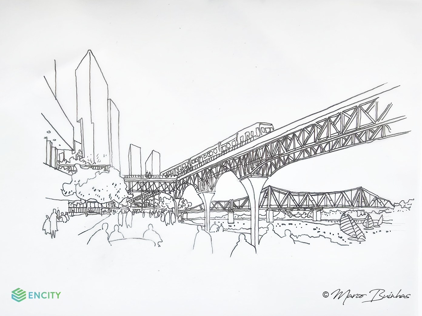
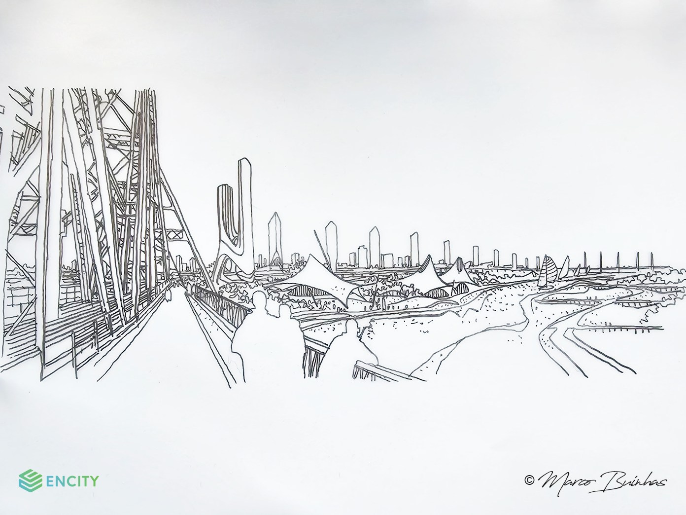 Figure 3 and 4. The author’s sketches of Hanoi and the Red River of tomorrow:
Feasible proposals for a green development axis in the near future.
References:
- Bertaud, Alain (2011). Hanoi Urban Structure: Spatial Development Issues and Potential. Washington, DC.: World Bank.
- Drakakis-Smith, David and Andrea Kilgour (2001). Sustainable urbanisation and environmental issues in Vietnam. In Living with environmental change: Social vulnerability, adaptation and resilience in Vietnam, W. Neil Adger, P. Mick Kelly and Nguyen Huu Ninh, eds, pp. 213-233. London and New York: Taylor and Francis Group.
- DiGregorio, Michael (2011). Into the land rush: Facing the urban transition in Hanoi’s western suburbs. International Development Planning Review, vol. 33, No. 3, pp. 293–319
- Đỗ, Phương Quỳnh (chủ biên) 2010. Hà Nội đôi bờ sông Hồng: Lịch sử văn hóa. Nhà Xuất bản Giao thông vận tải. (Do, Huong Quynh (2010). Hanoi on the banks of the Red River: Historical Culture. Transportation Publishing House.)
- Fanchette, Sylvie, eds. (2016). Ha Noi, a Metropolis in the Making: The Breakdown in Urban Integration of Villages. Petit Atlas Urbain. Marseille: IRD Éditions.
- Geertman, Stephanie (2010). Urban development trends in Hanoi & impact on ways of life, public health and happiness. Vietnamese Urban Planning Journal.
- Hersh, Seymour M. (1972). Dykes in Hanoi area represent 2,000-year effort to tame rivers. Available at: https://www. nytimes.com/1972/07/14/archives/dykes-in-hanoi-area-represent-2000year-effort-to-tame-rivers.html
- L., H. Phong (2015). The relationship between rivers and cities: influences of urbanization on the riverine zones – a case study of Red River zones in Hanoi, Vietnam. WIT Transactions on Ecology and The Environment, vol. 193.
- Labbé, Danielle (2021). Urban Transition in Hanoi: Huge Challenge Ahead. Singpaore: ISEAS
- Leducq, Divya and Helga-Jane Scarwell (2018). The new Hanoi: Opportunities and challenges for future urban development. Cities, vol. 72, pp. 70-81.
- Logan, William Stewart (2000). Hanoi: Biography of a City. UNSW Press.
- Nguyen, Vinh Phuc (1995). Hanoi Past and Present. Hanoi: Gioi Publishers.
- Tran, Dang Hong (2018). History of dykes in the Red River Delta. Available at https://nghiencuulichsu.com/2018/08/03/ lich-su-de-dieu-dong-bang-song-hong/
- Tran, Tri Doi (2010). The name of Red River: an evidence of cultural diversity in Vietnam history. The Third International Conference on Vietnamese Studies.

 VI