With its strategic location in the heart of Ho Chi Minh City, Thanh Da Peninsula is encircled by the Saigon River and lies less than 5 kilometers from the city center. Despite being one of the areas with the highest urban development potential, Thanh Da remains significantly underutilized. Fragmented residential patterns, inadequate infrastructure, low-lying flood-prone terrain, and poor regional connectivity have left Thanh Da as a blank spot in the city’s urban structure.
However, these very limitations create the foundation for shaping a new urban center—one that can integrate modern infrastructure, layered green spaces, smart urban ecosystems, and local identity within a resilient, adaptable, and far-reaching development framework.
Vision
The master plan, proposed by the Sasaki – enCity – UPI consortium, envisions Thanh Da as a new eco-cultural-creative urban center of Ho Chi Minh City. A modern, future-ready hub that honors the riverine landscape, the pioneering spirit of Southern Vietnam, and cultivates a richly diverse and identity-driven urban environment.
At the heart of Thanh Da is a large-scale central park along the Saigon River, linking functional zones through integrated public transportation and an expansive open space network. With a compact urban form and strategic connections to inter-regional transport axes, the plan positions Thanh Da as both a new growth pole and a model urban center for 21st-century Ho Chi Minh City.
Development strategies
The overall perspective of Thanh Da Peninsula viewed from the Southeast direction; from this viewpoint, the CBD (Central Business District) is located on the right side of the peninsula
1. A centre that grows with time
Thanh Da is planned as a compact urban center, with the CBD (Central Business District) located on the southern edge of the peninsula to ensure strong connectivity with Truong Tho and Thao Dien across the river. It is designed following a TOD model around Metro Line 7. As urban space on the peninsula forms a contiguous space, the CBD can expand flexibly over time—a critical condition for the growth of a commercial and service center.
This structure allows the CBD of Thanh Da to become a dynamic and long-term growth driver while coordinating inter-regional functions within Ho Chi Minh City’s polycentric urban network.
The overall master plan layout with Thanh Da Peninsula located at the center and the Truong Tho area on the right edge
2. Reuniting the community with the river
The Saigon River is not just a scenic element but is repositioned as an ecological and communal axis in Thanh Da’s urban structure.
The plan establishes a clear strategy to reconnect urban residents with the waterfront—not only through formal design, but by orienting the city’s spatial structure toward the river.
A central park lies adjacent to the river, embraced from the west and south by urban development, serving as both a core public space and an ecological buffer. Major roads are organized to converge toward the park and the river, maximizing visual access and connectivity from every neighborhood. Existing waterways are restored, and new internal canals are designed to bring the riverine landscape deeper into the urban core—expanding water features, improving climate and stormwater regulation, and enhancing riverside living experiences.
This strategy shapes Thanh Da into a truly river-oriented city, where natural flows structure the urban living environment rather than merely act as a scenic backdrop.
Thanh Da was historically the gateway to Gia Dinh Citadel and Saigon City. The peninsula also lies on the spiritual axis of the former Gia Dinh Citadel, forming a line that connects from the Independence Palace along Le Duan Boulevard toward the peak of Langbiang Mountain (referred to as Than Quy Mountain in the book Dai Nam Nhat Thong Chi)
The urban structure of Thanh Da is designed to honor heritage elements and maximize connections with open spaces, aiming to create a city rich in local identity
3. Celebrate heritage, heal nature
Thanh Da historically served as the northern gateway to Gia Dinh–Saigon, with the Thanh Da ferry terminal marking the end of a symbolic axis extending from the Independence Palace toward Langbiang Peak—considered the sacred mountain shaping the feng shui of Southern Vietnam and the source of the Dong Nai River, the mother river that brings prosperity to the Southeast region.
In the master plan, the Le Duan–Thanh Da axis is reimagined as a symbolic cultural corridor, linking past and present in a new urban framework.
Heritage sites such as Binh Quoi Tay Communal House, Long Duc Pagoda, and Mai Thon Church are preserved in place and integrated into open public spaces, serving as “memory anchors” within the future city. At the same time, multi-layered ecological corridors—including riverside parks, green belts, urban forests, and open water systems—are introduced to restore ecological functions across the peninsula and enhance climate resilience.
4. Regional linkages to anchor the centre
Thanh Da is planned as a strategic link within Ho Chi Minh City’s polycentric urban network.
Infrastructure is organized to ensure regional connectivity in both East–West and North–South directions. The East–West corridor acts as the backbone connecting Thanh Da with Tan Son Nhat Airport, Thu Thiem, Truong Tho, and the High-Tech Park.
Metro Line 7 passes through the southern part of the peninsula and becomes the main public transport artery, linking Thanh Da with key city centers such as Thu Thiem, Truong Tho, the High-Tech Park, and Phu My Hung. It is complemented by main roads and river-crossing bridges to ensure multi-directional access.
In particular, the connection to Thao Dien is planned as a light mobility corridor—prioritizing clean transport, pedestrians, and green space—reducing infrastructure stress on existing neighborhoods while ensuring effective regional integration.
Southern Museum of Culture & Nature
The riverside market wharf recreates the bustling “on the wharf, under the boat” scene of old Saigon, set against a backdrop of contemporary architecture
5. A place of places
Thanh Da’s spatial strategy does not aim for uniformity, but rather celebrates urban identity diversity through open space design, varied architectural language, and layered living experiences. Functional zones such as riverside arts districts, eco-resorts, commercial promenades, and modern high-rise neighborhoods are arranged in a polycentric pattern. Each zone carries its own spatial logic and design language, but all are interconnected through a continuous public space network. In addition, several iconic facilities are included:
– The Museum of Southern Culture and Nature,
– A theater and performing arts center,
– A floating market along the river,
– Public squares, pedestrian bridges, landmark towers, and more.
This diversity gives form to a multi-layered urban center—neither monotonous nor formulaic—but one where residents can discover themselves in a mosaic of distinct “places.” The Thanh Da master plan does not seek to recreate the Saigon of the past but instead looks ahead to a new urban center—modern, flexible, adaptive, and rich in cultural depth. Here, water becomes a structuring element. The past is honored, not imitated. And the future is imagined through the lens of local identity. Thanh Da is more than a development project—it is a statement of how Ho Chi Minh City can grow: from the land, from the water, from memory – and into the future.


 The overall perspective of Thanh Da Peninsula viewed from the Southeast direction; from this viewpoint, the CBD (Central Business District) is located on the right side of the peninsula
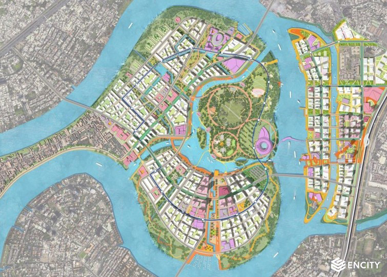 The overall master plan layout with Thanh Da Peninsula located at the center and the Truong Tho area on the right edge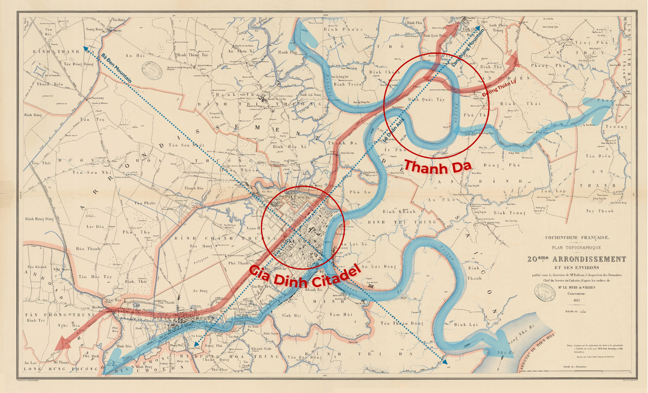
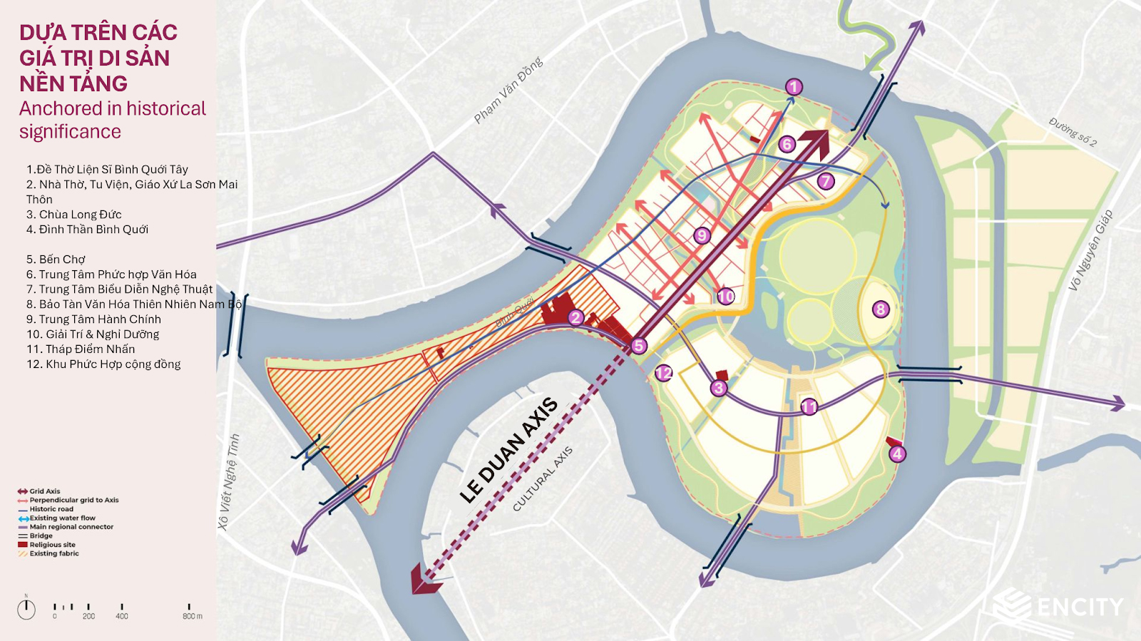 The urban structure of Thanh Da is designed to honor heritage elements and maximize connections with open spaces, aiming to create a city rich in local identity
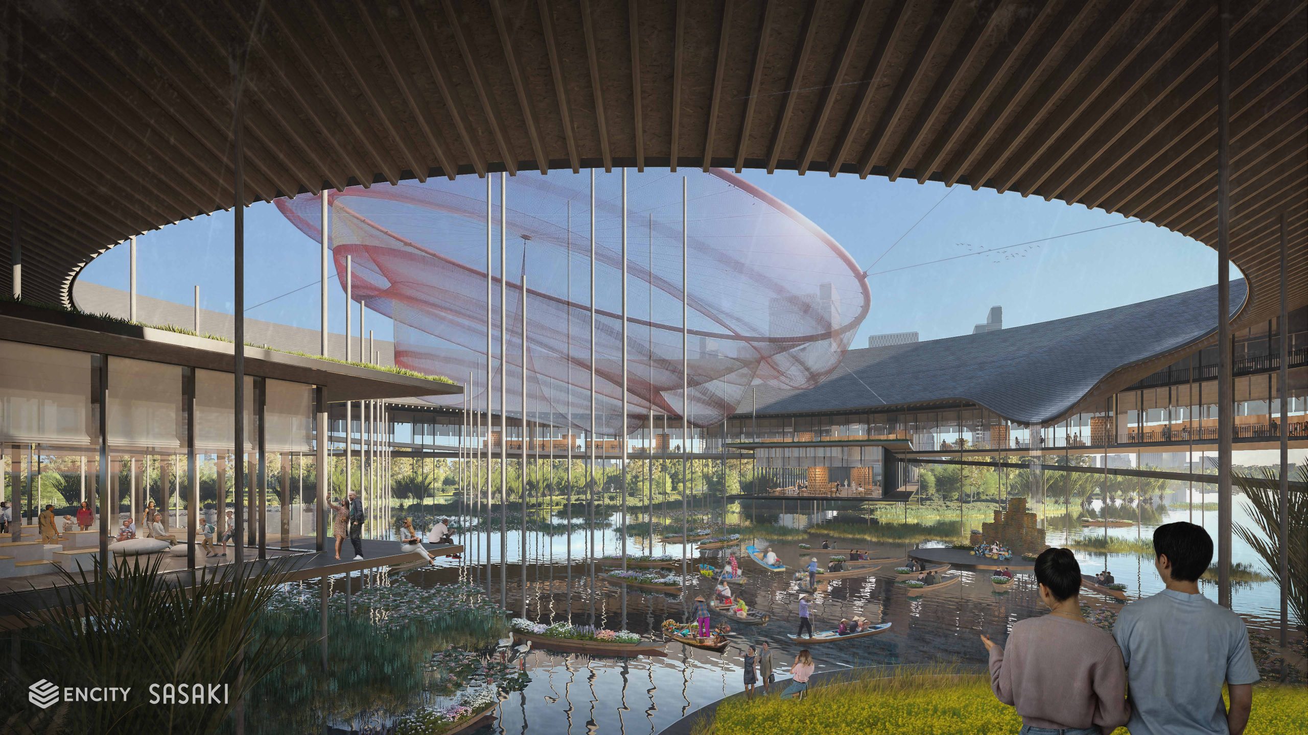 Southern Museum of Culture & Nature
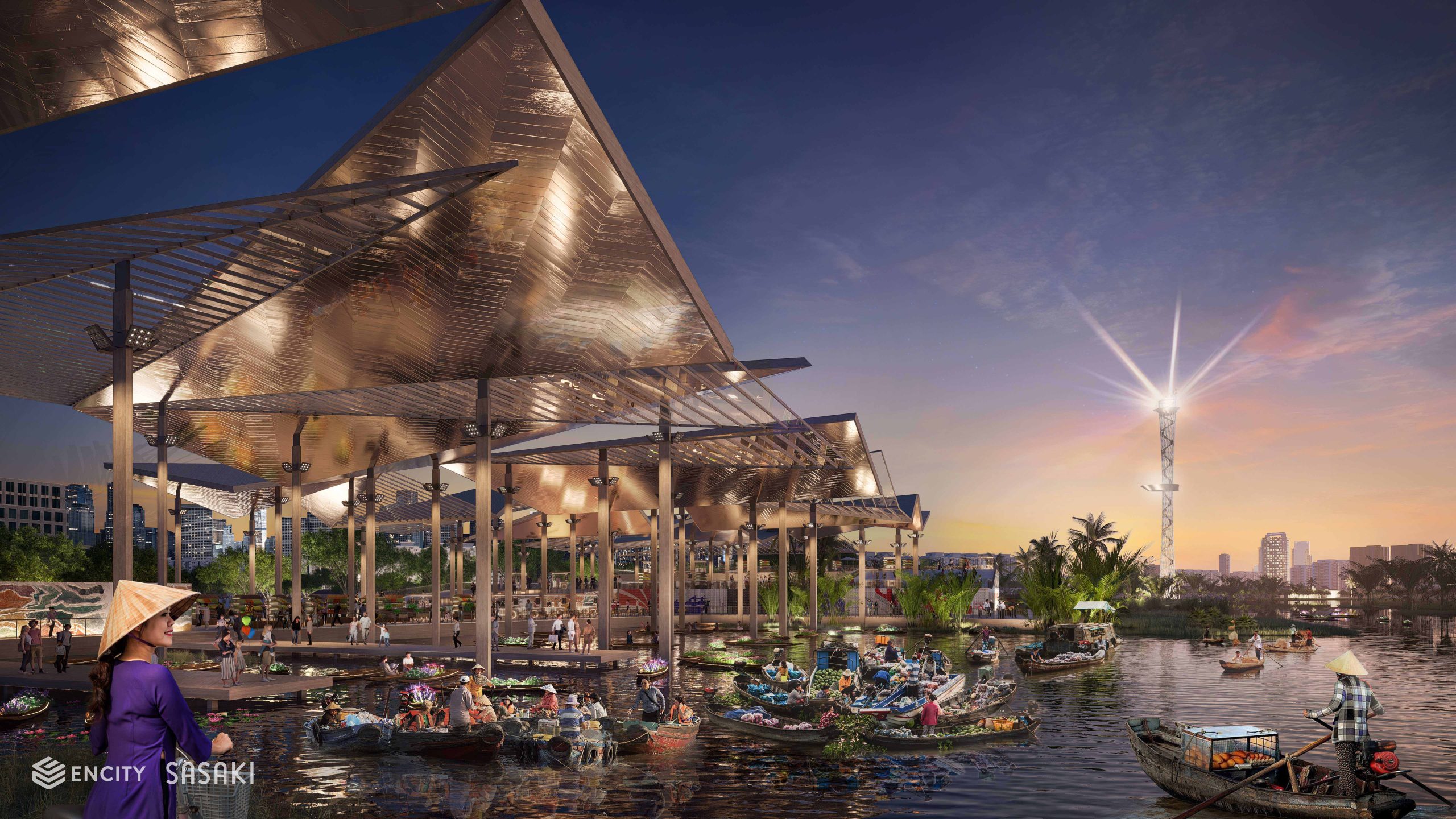 The riverside market wharf recreates the bustling “on the wharf, under the boat” scene of old Saigon, set against a backdrop of contemporary architecture
 VI
VI