

I once participated in a project aimed at addressing lead water contamination in Malden, Massachusetts, a city of approximately 70,000 residents. Our mission was to map heavily contaminated areas and propose a phased action plan.
Working alongside local officials, we integrated lead contamination maps, hosted on an accessible online platform, with spatialized demographic data including income, race, and homeownership status. This approach enabled us to rapidly pinpoint vulnerable communities with high lead levels that required immediate government attention for water pipe replacement.
The collaboration proved highly effective, yielding tangible, actionable results. This success stemmed from Malden’s strategic decision early on: embedding Geographic Information Systems (GIS) into a management platform accessible to both technical experts and local staff.
Global success stories
In the United States, local administrative units enjoy significant autonomy, managing independent budgets, collecting taxes, and delivering public services. This strong decentralization, combined with direct citizen accountability, has driven widespread GIS adoption. A 2003 Public Technology Inc. study revealed that approximately 97% of local governments serving populations of over 100,000 and 88% of those serving 50,000-100,000 residents had implemented GIS technology.
Japan presents a similar success story. By 2025, GIS adoption reached 95% across local and national agencies for urban planning, public services, and disaster management. According to Astute Analytica, GIS implementation helped Japanese authorities boost public infrastructure project efficiency by 40% and cut natural disaster response times by 30%.
Vietnam’s local government landscape is undergoing a dramatic transformation through commune and ward consolidation, coupled with enhanced decentralization of infrastructure management, land administration, finance, and digital transformation to the commune level. The country has streamlined from over 10,000 commune-level units before consolidation to just over 3,000 today.
This consolidation has not merely expanded management scope—consider Ba Diem Commune in Ho Chi Minh City with over 200,000 residents, or Buon Don Commune in Dak Lak spanning more than 1,100 km²—but has also introduced significant operational challenges. Communes and wards now shoulder critical responsibilities, managing numerous citizen-facing procedures, including land administration and infrastructure oversight.
Against this backdrop, building local officials’ spatial data processing capabilities has become imperative. Yet traditional GIS systems remain complex and technically demanding. In Vietnam, GIS deployment typically occurs at provincial levels or above, primarily used by data specialists. Consequently, implementing user-friendly GIS platforms emerges as the optimal solution, empowering commune and ward officials to manage effectively while making citizen-centered decisions.
Measure right, build bright: precision planning power

One persistent challenge for planning professionals in Vietnam involves managing heavy CAD files and conducting manual measurements and data comparisons, processes prone to costly errors. Provincial and municipal statistics consistently show that land administration bottlenecks stem primarily from certificate issuance errors, resulting in overlapping files, inaccuracies, and time-consuming re-verification processes. Post-consolidation, commune and ward officials will directly oversee land certificate issuance, confronting these complex challenges head-on.
enCity’s technical team has developed a Smart planning management platform built on GIS databases with an intuitive interface. The platform displays land use data instantly with a single click. Measurement operations are streamlined and rapid, ensuring information accuracy and seamless file export capabilities.
The platform can seamlessly integrate mapping data with diverse datasets covering land use, technical infrastructure, social infrastructure, transportation, and natural resources within one user-friendly system, optimizing information flow across departments and administrative levels.
Data-driven leadership in action
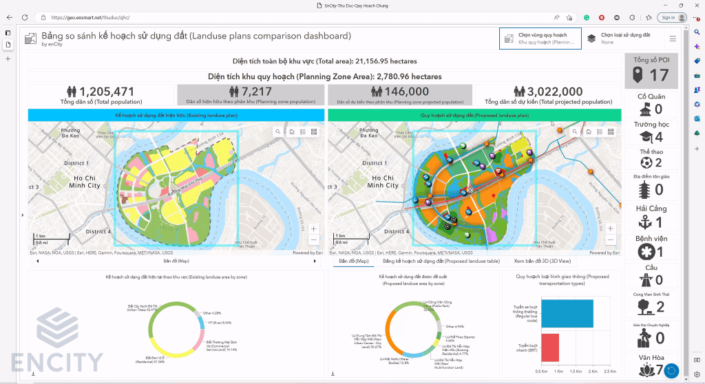
Beyond certificate issuance, extensive new authorities are shifting to commune level, including land allocation, leasing, and use-purpose conversion. This transition demands that commune officials develop faster, more precise decision-making capabilities.
enCity’s Smart planning management platform serves as an indispensable decision-support tool. Its interactive dashboard with advanced filtering capabilities processes critical metrics, including population dynamics, land use ratios, and occupied areas, enabling commune and ward officials to make evidence-based decisions aligned with planning objectives. Furthermore, with generative AI integration, the platform will transcend data processing to recommend optimal solutions, revolutionizing decision-making speed and intelligence.
Trusted citizen-centered governance

Being the administrative tier engaging directly with citizens, communes and wards require robust systems for community interaction and consultation, empowering residents to shape their living and business environments.
A compelling example is enCity’s online mapping platform connecting with Hanoi’s youth. Through this visually engaging, interactive map, over 16,000 young people and students positioned symbols representing their aspirations and dreams for the capital. Such platforms enable planners and administrators to reach citizens directly and hear from those they serve.
The future of local governance hinges on leveraging technology to streamline management processes, enable practical data-driven decisions, and empower citizens. A highly interactive yet accessible GIS platform represents the key to achieving these objectives, democratizing spatial data access beyond technical experts alone. Spatial data’s transformative power will strengthen local government capacity for informed decision-making, foster citizen trust, and collaboratively build thriving communities.
Ngoc Pham
Associate, Policy + Planning

 VI
VI