

For years, Can Gio has represented the furthest point Ho Chi Minh City could stretch toward the ocean. Across the water in Ba Ria-Vung Tau Province, industrial zones, ports, and oil and gas infrastructure have taken shape, but as isolated clusters. Provincial merger would allow Ho Chi Minh City’s boundaries to embrace the entire Ganh Rai Bay southeast of Can Gio, finally opening the great maritime gateway that has remained elusive for over a century. The moment has arrived for the city to develop an oceanic vision worthy of its international megacity ambitions.
The maritime dream and Saigon’s commercial port heritage
Expanding administrative boundaries represents far more than bureaucratic restructuring—it marks a spatial pivot that allows the city to fundamentally reimagine its development trajectory: from an inward-facing center to a globally networked maritime metropolis. Under this new configuration, the Ganh Rai Bay area south of Can Gio, once Ho Chi Minh City’s most distant frontier, transforms into a strategic development epicenter where deep-water port potential, heavy industry, renewable energy, and precious mangrove ecosystems converge.
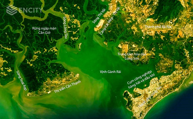
The Ganh Rai Bay, encompassing both Can Gio and the Ba Ria-Vung Tau mountains of Thuy Van, Long Son, Ganh Rai, and Ba Ria itself, functions not only as a strategic economic zone but also lies within a geographical and feng shui system identified during the Nguyen era. Historical accounts in the “Decriptive geography of the land of Gia Dinh in South Vietnam” (“Gia Dinh Thanh Thong Chi”), circa 1820, and “Dai Nam Comprehensive Encyclopaedia” (“Dai Nam Nhat Thong Chi”), circa 1909, describe this entire region as the downstream terminus of the Than Quy mountain system, Southern Vietnam’s ancestral range, stretching from the Lam Vien highlands through Tay Ninh’s Ba Den Mountain before flowing to the sea via low mountain chains including the Nui Lon-Nui Nho cluster at Vung Tau. Ancient Gia Dinh, positioned to “sit facing Qian, look toward Xun,” was planned along this feng shui axis, oriented southeast toward what is now Ganh Rai Bay. This reveals that Can Gio and Ba Ria-Vung Tau have shared landscape and cultural connections since their founding.

Figure 2: Railway development plan for Indochina. Source: Paul Doumer (1905). Indochina (Memoirs). Translation by Luu Dinh Tuan, Hieu Constant, Le Dinh Chi, Hoang Loang, Vu Thuy (2015). World Publishers, Hanoi.
Worth remembering: Saigon’s commercial port, predecessor to today’s Ho Chi Minh City port complex, was once regarded as French Indochina’s most vital gateway. Positioned at the confluence of two fertile hinterlands, connected by river networks reaching north to Phnom Penh, Saigon became the world’s largest rice export hub in the early 20th century. Yet its ambition to become the Far East’s premier commercial port went unrealized because the port sat deep inland, 70 kilometers from open water, without the autonomous authority to implement breakthrough reforms like Singapore or Hong Kong.
Consolidation creates space for grand vision
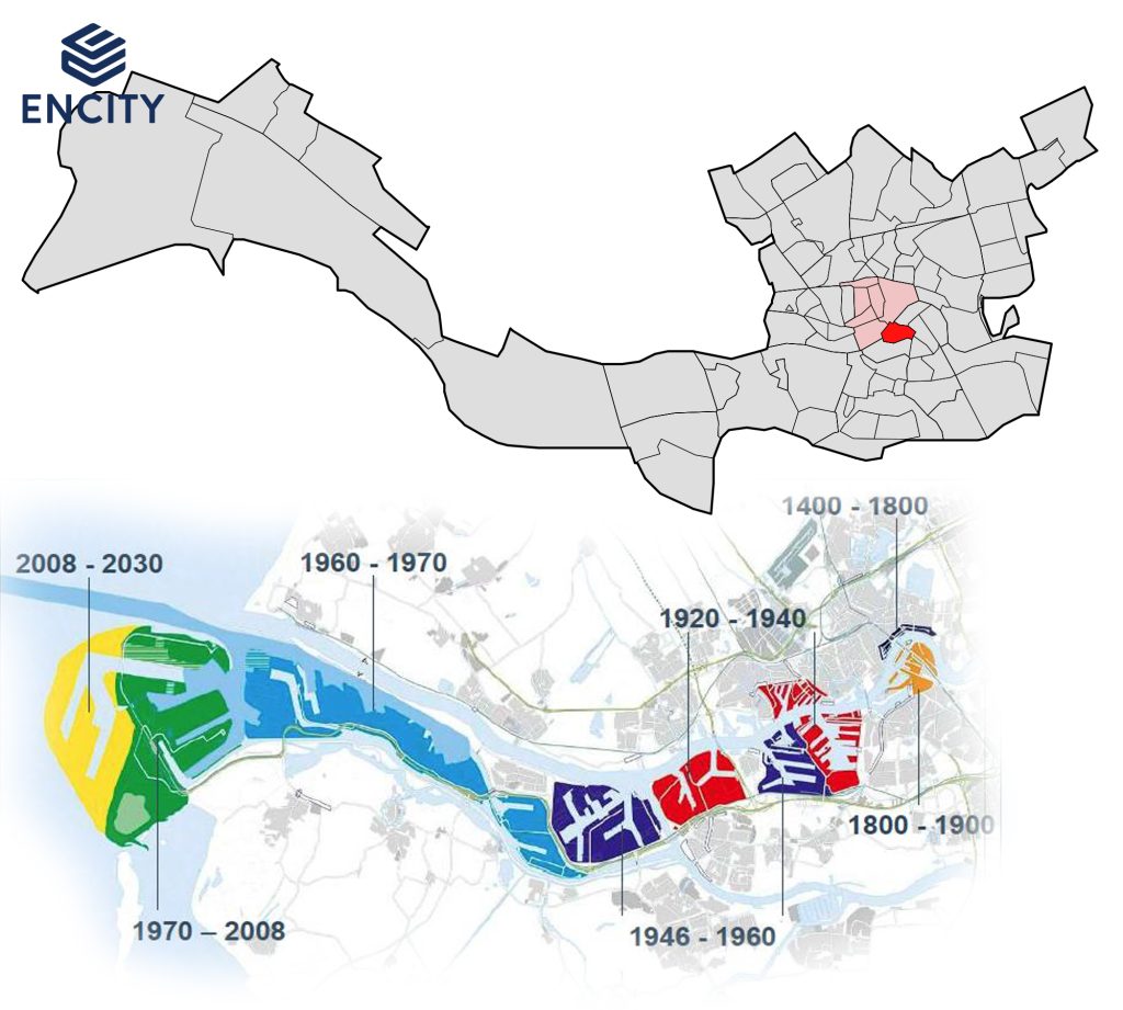
The idea of expanding administrative boundaries for port development—impossible for Saigon a century ago—becomes a reality with Ba Ria-Vung Tau integration. This mirrors Rotterdam’s evolution as Europe’s largest commercial port: the city’s boundaries extended precisely along the port’s seaward reach, enabling municipal authorities to control and seamlessly integrate port planning, logistics, and urban development. Rotterdam’s story shows that for seaports to reach far, cities must advance alongside them. Ho Chi Minh City now faces a parallel opportunity: not simply to expand spatially toward the sea, but to restructure its entire economic development model around maritime advantages.
In the past, Ho Chi Minh City pursued multiple seaward strategies that remained incomplete. River ports like Saigon, Cat Lai, and Hiep Phuoc faced constraints from shallow navigation channels and limited expansion potential. Can Gio, despite far superior geography for deep-water port development, lacked regional coordination mechanisms and failed to attract proportionate investment. But with Ba Ria-Vung Tau boundary integration, the entire eastern and western shores of Ganh Rai Bay fall under unified planning authority. This represents a rare convergence where geography, institutions, and international economic trends simultaneously create a historic opportunity for Ho Chi Minh City to redefine its maritime role and coastal development space. Vietnam now has its chance to forge a continental-scale maritime economic center.

The Can Gio-Phu My-Vung Tau triangle, comprehensively planned and integrated, could evolve into an interconnected bay region rivaling Tokyo, San Francisco, or Hong Kong-Shenzhen. Here, eco-urban districts, seaports, industrial complexes, research centers, and nature reserves would not exist in isolation but function symbiotically within balanced, adaptive development frameworks.
Coastal urban laboratory of the future
Can Gio must serve not merely as an eco-tourism zone or new urban district, but as a “coastal urban laboratory”, where high-technology models, floating cities, smart ecosystems, and green transition policies undergo testing and scaling. Meanwhile, the Phu My-Long Son-Thi Vai cluster continues as the city’s industrial and energy powerhouse, upgraded toward low-carbon, circular, and environmentally responsible industrial models.
The region’s natural endowments—from the Thi Vai-Long Tau shipping channel to coastal topography and mangrove ecosystems—create exceptional conditions for simultaneously developing maritime economy and ecological infrastructure. This landscape enables the creation of the Can Gio International Transshipment Port, the expansion of the Long Son energy hub, and the establishment of a new ecological coastal city in Can Gio, scaled to match the population of a first-tier city.
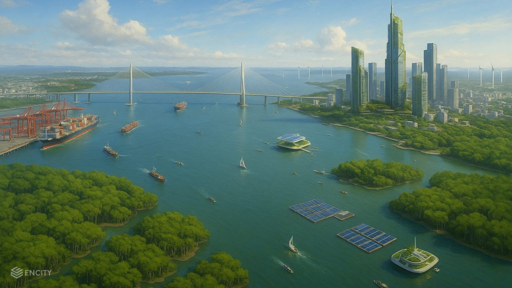
Conservation and development need not stand as competing goals. Rather, ecosystem preservation, like Can Gio’s mangrove forests, enhances disaster resilience, protects coastal infrastructure, and elevates ecological real estate values. New planning must transition from “purely hard infrastructure” approaches toward hybrid models incorporating “soft infrastructure” that harnesses nature-based solutions: forest expansion, sand barrier systems, and floating or semi-floating urban development that adapts to sea-level rise.
This model has moved beyond theory. The Netherlands plants forests and engineers sediment deposits for coastal defense. The United States restores the Mississippi Delta mangroves as biological barriers. These practices translate directly to Can Gio, positioned to become the 21st century’s premier climate-ecology-urban laboratory.
Particularly as global trends shift toward renewable energy and green growth, Ganh Rai Bay could spearhead Vietnam’s energy transition pathway. Offshore wind farms, floating solar installations, storage systems, and digital energy management centers can integrate into regional spatial planning while linking to research-training-technology transfer zones serving mid-century carbon neutrality objectives.
The consolidation creates strategic action opportunities. Ho Chi Minh City needs robust bay-wide coordination mechanisms, combining strategic public investment, transparent public-private partnerships, and proactive engagement from constituent municipalities. Can Gio’s development cannot unfold as isolated real estate speculation. It demands a national program encompassing coastal urbanization, green transition, and circular economy principles.
This great bay region, with sufficient long-term vision, could generate a second growth engine complementing the Saigon-Thu Duc corridor. No longer the city map’s distant edge, Can Gio and Ganh Rai Bay emerge as the launching point for an ocean-oriented Ho Chi Minh City: sustainable, integrated, and future-directed.
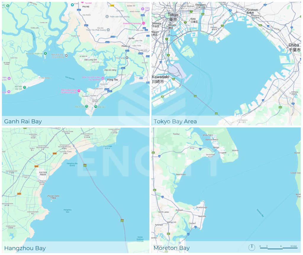
Appendix: case studies of major global bay regions

*Population encompasses full metropolitan region surrounding each bay. Data current to 2023–2024 from national statistics and United Nations sources.
Ganh Rai Bay quick comparison
Current population: ~900,000; projected 1.5–2 million upon completion of sea-reclamation urbanism and population redistribution.
Water surface area: ~1,000 km²; equivalent to Moreton Bay, representing 55% of Tokyo Bay proper.
Conservation ratio: Can Gio Biosphere Reserve encompasses >75,000 hectares of mangroves (≈75% of bay area)—the highest conservation percentage among comparison cases.
Dzung Do Nguyen
enCity Senior Principal, Planning + Urban Design

 VI
VI